dickdave.htm

Home Weather Service Primer 146745repwork.htm may3rdmeeting.htm 147000.htm above and beyond.htm 2004.htm award.htm dave.htm dickdave.htm


Storm Research Project 04-001
KC5ZNB, DAVE WALLACE: Meteorologist
KB5LHL, DICK DUKES: Photographer
 

ARE YOU INTERESTED IN SEVERE WEATHER?  EVER THOUGHT ABOUT BECOMING A STORM SPOTTER?  KB5LHL AND I, KC5ZNB, WOULD LIKE TO INVITE YOU TO COME ALONG WITH US ON DICKS FIRST STORM RESEARCH PROJECT.  RIDE WITH US WHILE WE TRACK THE BIRTH AND LIFE OF SUPERCELL THUNDERSTORMS AS THEY ROAR ACROSS SOUTHWEST OKLAHOMA.  TELL US WHAT YOU THINK OF THE RIDE.  WE WILL TAKE THIS TRIP AGAIN AND PROMISE NOT TO DENT YOUR TRUCK!


3-27-04 11:14 AM Abundant low level moisture over Altus AFB, Oklahoma. This is the fuel for thunderstorms which will fire by early afternoon in Western Oklahoma. It is ironic that this photo, if taken on Feb 22, 1975, May 20, 1977, and May 11, 1982, would have shown tornados on the flight line.


11:46 AM Breaking out of the low overcast west of Altus where surface heating will help initiate convection. Modest beginnings of super cell #1.


11:49 AM Rapid development northern Harmon Co. NW of Hollis, Ok


12:08 PM Storm has developed a flanking line and is taking on supercell characteristics. Nickel size hail is falling at 12:25 PM. 11 miles South of Erick, Oklahoma. We report this directly to the National Weather Service Norman, Oklahoma via the 146.715 repeater and a severe thunderstorm warning is issued for the Sayre, Oklahoma area.  20 minutes later baseball hail was falling SW of Sayre Oklahoma.


12:42 PM As supercell moves thru Sayre, Oklahoma and crosses I-40 it produces baseball size hail and at 12:45 PM a rotating wall cloud. Other ham operators had converged on this storm by now and were relaying good reports to the National Weather Service in Norman Oklahoma. We chose to return to the SE to track the developing towers of another supercell!


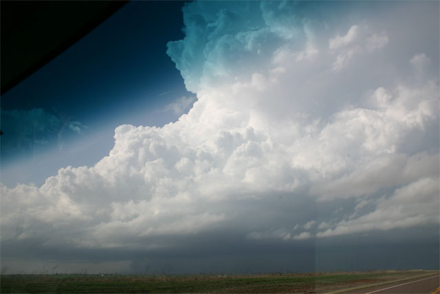
1:16 PM Looking back north at overshooting tops North of I-40.  Tornado reported, 5 WSW Vici, Oklahoma at 1:20PM.


1:30 PM Rapid development of CB, TCU SW of Reed, Oklahoma.


2:00 PM continued rapid development just south of Reed, Oklahoma. As the updraft passes overhead, it was already strong enough to calm a 25 knot inflow.


2:33 PM Sunburst over flanking line looking SW, near Reed, Oklahoma.


2:41 PM from east of Reed, Oklahoma looking North into flanking line of fully developed supercell at right. 1 inch hail at 3:17 PM as storm passes over Willow, Oklahoma.


3:22 PM Mature supercell thunderstorm near Retrop, Oklahoma producing 1 inch hail.


3:31 PM from the NW side of supercell looking SE toward Retrop, Oklahoma. This is the area to watch for wall cloud development.


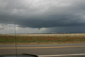
3:32 PM 5 E of Retrop, Oklahoma looking NNE at funnel cloud, underneath the right rear flank and rain free cloud base.


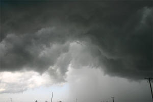
3:44 PM small funnels observed along with rotating scud. Note the appearance of RFD from left.


3:58 PM the business end of a classic supercell thunderstorm. 1 inch hail moving into Burns Flat, Oklahoma.


4:11 PM underneath the storm we find moderate rotation and the RFD punching in from the West


4:15PM rotation is centered in the photo with RFD coming in from West. Looking N from 10 miles South of Clinton, Oklahoma.


4:26 PM another funnel cloud observed to WNW of Cordell, Oklahoma


4:38 PM In an area of rotation this heavy downpour must be watched carefully before driving into it.


5:04 PM A person who stops before he pulls over! Driving safety is most important. Chasers who do not practice safety can be more dangerous than the storm itself.


5:19 PM as sirens wail in Weatherford, Oklahoma funnel clouds are observed just south of I-40.


5:27 PM South Weatherford, Oklahoma wall cloud and the tail cloud are crossing I-40.


5:55 PM Severe supercell departing the Weatherford, Oklahoma area to the NE.  Note: overshooting top reappears.


6:44 A last look at a supercell thunderstorm about 6 hours after birth on the convective currents of SW Oklahoma. At 6:48 PM a tornado touched down in Canadian County, 2 miles south of Okarche, Oklahoma. Fortunately, this one storm only manages to scare a lot of people, inconvenience a few more, and for some provide study material, both on pixels and memory.
 

These supercell storms of March 27, 2004 produced 5 brief tornados and very large hail. Several of these photo's reveal a clue as why the tornadoes were not more violent. Did you spot it? Want to learn more about the dynamics of a supercells? On our next run we will explain more about the dynamics of supercell and how we predict their formation days in advance. Ride with us on SRP #2 coming soon! KC5ZNB
Do you know the answer to the above questions? if so submit your answer below, or just leave us a note and tell us what you think!

Add Your Comments


All images on this page are copyrighted and are the property of Richard (Dick) Dukes, KB5LHL. The images cannot be reused, reproduced, distributed, modified, or published without the prior written permission of the copyright owner. These images are optimized to make the page load faster, the full high resolution printable image  may be purchased by contacting Dick. Contact Dick by email: stu-dent@tds.net


ALL PICTURES ON THIS PAGE ARE Copyright © 2004 Richard "Dick" Dukes KB5LHL
Copyright © 2001 by [SWIRA]. All rights reserved.
Revised: 04/29/15 09:12:16 -0700.
Web page by NZ5C   

To contact NZ5C  email